
Surprising Satellite Images Reveal How Overflowing Manchhar Lake Submerged Villages
The National Aeronautics and Space Administration (NASA) satellite photographs depict the destructive overflow of the Manchhar Lake in Jamshoro and Dadu districts in Sindh.
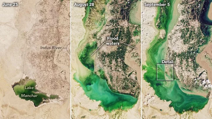
According to the specifications, the photographs were collected by NASA’s Operational Land Imager instrument on the Landsat 8 satellite on June 25, August 28, and September 5, this year. They show how far the lake and its overflow have swamped the settlements.
Pakistan’s biggest freshwater lake is said to have flooded hundreds of communities, affecting over 100,000 people.
It grew rapidly as a consequence of the country’s record-breaking monsoon periods this year, and additional overflow might result in a disaster harming countless people and homes.
The before and after satellite photos of Manchhar Lake are shown below.
Another image represents how man-made holes, such as the one at the Main Nara Valley (MNV) drain canal, diverted the raging waters in a new direction in order to mitigate the damage caused by Manchar Lake’s overflow.
Breach of Lake Manchar
The lake’s overflow compelled officials to make deliberate holes in order to release the water in a controlled way, saving the surrounding towns and cities. However, several villages were flooded as a result of the spilt water being directed to where they were situated.
Read Also: Government describe their own cyber security cells as incompetent.
Earlier that day, on September 4, the authorities broke the lake, affecting around 400 settlements and 135,000 people. However, in one case, the water stress created another break.
The people living nearby were warned to evacuate before the planned breaches flooded the surrounding regions, but most were hesitant to leave their homes and cattle.
Sindh’s Irrigation Minister, Jam Khan Shoro, stated that the water level has begun to drop after the excavation of holes, adding that numerous densely populated cities would have been flooded if the action had not been taken.